Overview
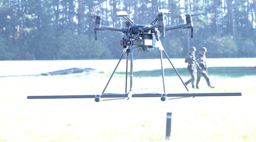
The DMAG System is an autonomous aerial survey platform for low altitude total-field magnetic surveying. Combining a DJI Matrice 210RTK with custom built sensor hardware and AGS software, it is capable of autonomously flying survey grids at altitudes down to just 50cm above ground.
The DMAGv210 was fitted with four 3-axis fluxgate magnetometers and two GPS antennas, which enabled the recording of data across a wide area with a track width of 2 meters. The dual GPS facilitated the capture of position and direction data, continuously recorded and displayed in real-time on the remote control display.
The UAV is an autonomous hovering platform with four swivelling rotors arranged in a plane to generate lift or propulsion. Disturbances caused by flight movements and rotor currents are compensated during data acquisition. The magnetometer and positioning systems processed existing position and sensor data in real-time. For this purpose, SeaTerra uses the software AGSDrone", specially developed for explosive ordnance detection. The In-house software "AGSProc" makes a data analysis and data interpretations of collected data.
Specifications
| Battery | 24min |
| Low battery alert | 1 |
| Low battery alert information | Yes |
| Rechargeable | 1 |
| Operating time | 10 hours |
| Operating time information | 10 |
| Battery charger provided | 1 |
| Battery charger information | standard |
| Length | 643 mm |
| Weight | 7 kg |
| Transport case provided | 1 |
| Transport case information | Waterproof, crushproof, dustproof |
| Transport case weight | 9 kg |
| Case dimensions | 67.6 x 52.5 x 37.8 cm |
| Factory support | Yes |
| Possible to rent | 1 |
| Additional equipment | Thermal camera, LIDAR, Camera |
| Maximum speed | 80 km/h |
| Flight / trip planning software | 1 |
| Live data transmission | 1 |
| Image processing software | 1 |

